Trail Walking La Chapelle-de-la-Tour - Chapelle de la tour - Photo
© OpenStreetMap contributors
Length
Length
11 km
Max alt
Max alt
456 m
Uphill gradient
Uphill gradient
130 m
Km-Effort
Km-Effort  
12.7 km
Min alt
Min alt
386 m
Downhill gradient
Downhill gradient
131 m
Boucle
Boucle
Yes
Creation date :
2023-01-09 18:44:52.798
Updated on :
2023-01-09 18:51:13.338

(0 Reviews)

Walking
Walking
2h53
Difficulty : Medium

Scan this QR Code to open this trail in the SityTrail application

FREE GPS app for hiking

Logo SityTrail SityTrail

IGN / Geographical institutes

Download SityTrail from the App Store Download SityTrail from Google Play

Logo SityTrail SityTrail World

The world is yours!

Download SityTrail from the App Store Download SityTrail from Google Play Download SityTrail on Huawei AppGallery

About

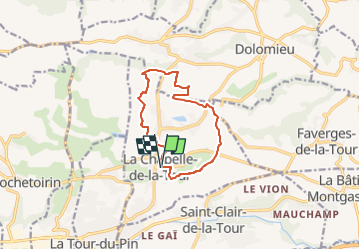
Trail Walking of 11 km to be discovered at Auvergne-Rhône-Alpes, Isère, La Chapelle-de-la-Tour. This trail is proposed by Ninie38MD.

Description

boucle sur la chapelle de la tour . on passe par la forêt Molette

Elevation profile

Photos

Positioning

Country:
France
Region :
Auvergne-Rhône-Alpes
Department/Province :
Isère
Municipality :
La Chapelle-de-la-Tour
Location:
Unknown
Start:(UTM)
692350 ; 5050896 (31T) N.

Trails nearby

Trail Motor Saint-Clair-de-la-Tour - rando quad - Photo
Motor
lescimes260

Motor

Easy
(2)
Saint-Clair-de-la-Tour, Auvergne-Rhône-Alpes, Isère, France
80 km | 103 km-effort
3h 42min
Yes
Trail Walking Vignieu - Vignieu - Saint Chef - Canal des moines  - Photo
Walking

Walking

Very difficult
Vignieu, Auvergne-Rhône-Alpes, Isère, France
15.6 km | 20 km-effort
4h 34min
Yes
Trail Quad Saint-Clair-de-la-Tour - Remise en forme de printemps  - Photo
Quad
lescimes260

Quad

Easy
Saint-Clair-de-la-Tour, Auvergne-Rhône-Alpes, Isère, France
80 km | 105 km-effort
4h 11min
No
Trail Quad Saint-Clair-de-la-Tour - G et G 3 - Photo
Quad
lescimes260

Quad

Medium
Saint-Clair-de-la-Tour, Auvergne-Rhône-Alpes, Isère, France
110 km | 146 km-effort
6h 41min
No
Trail Motor Saint-Clair-de-la-Tour - rando relax - Photo
Motor
lescimes260

Motor

Easy
Saint-Clair-de-la-Tour, Auvergne-Rhône-Alpes, Isère, France
34 km | 42 km-effort
2h 36min
Yes
Trail Walking Saint-Jean-de-Soudain - 2013 09 15 St-Jean de Soudain - Photo
Walking
lechner

Walking

Very easy
Saint-Jean-de-Soudain, Auvergne-Rhône-Alpes, Isère, France
16.7 km | 20 km-effort
1h 14min
Yes
Trail Motor Saint-Clair-de-la-Tour - rando du parallèle - Photo
Motor
lescimes260

Motor

Medium
Saint-Clair-de-la-Tour, Auvergne-Rhône-Alpes, Isère, France
82 km | 113 km-effort
3h 43min
Yes
Trail Motor Saint-Clair-de-la-Tour - Rando Ablert et Mickael - Photo
Motor
lescimes260

Motor

Easy
Saint-Clair-de-la-Tour, Auvergne-Rhône-Alpes, Isère, France
85 km | 113 km-effort
4h 13min
Yes
Trail Motor Saint-Clair-de-la-Tour - rando - Photo
Motor
lescimes260

Motor

Very easy
Saint-Clair-de-la-Tour, Auvergne-Rhône-Alpes, Isère, France
96 km | 118 km-effort
6h 7min
No


Close
My subscriptions